Nephin Mountain Walk in Co. Mayo
The County of Mayo possesses an amazing variety of landforms, scenery, history and heritage. It is a haven for hillwalkers and lovers of the great outdoors, although not frequented by many because of the seeming peripheral nature of the region.
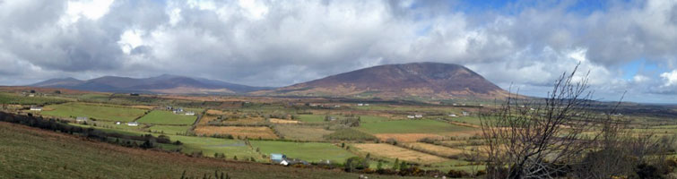
Among the most interesting of Connaught's mountains is Nephin, which has been climbed and revered for generations. Nephin is a majestic mountain, which dominates the landscape for miles around.
It is a conical shaped quartzite mountain standing alone overlooking Lough Conn, not even connected to the neighbouring Nephin Beg mountain range.
It is the second highest mountain in Connaught, second only to Mweelrea also in County Mayo, overlooking Killary Harbour.
Access and starting point
Access is in relatively easy with Ireland West Airport Knock less than an hour away. It is also within easy reach of Westport, Castlebar, Ballina and Crossmolina. The route we have chosen for the ascent is approached from it's western side.
To reach the starting point follow the R312 road from Castlebar to Belmullet, passing the beautiful fishing lake of Beltra.
After passing Beltra school keep an eye out for a forest on the southern end of the mountain.
After passing the junction of the R312 and R317 the road passes parallel to the Crumpaun River (Abhann an Chrumpain Bhui) for a while.
The Route
The total distance of the route is approx. six miles (10km) and the walking time is about 4 hours. The mountain is contained in the Ordinance Survey Map Discovery Series Sheets 23 or 31.
At the entrance to the forest at Pruglish (grid ref. G084 047), there is room to park your car. Enter the forest at the gate and follow the forest road as far as a house, and continue by following the forest fence until the slopes of Nephin come into view. You will pass under an E.S.B.electricity transmission line.
As you begin to climb above the forest the slopes are heather clad and quite hillocky. There are some rocky outcrops and in some instances the slopes consist of scree or boulders. As you begin to gain height some cairns come into view. As you approach these cairns you may be fooled into thinking you have reached the summit, only to find another cairn lying ahead.
The journey seems endless at times. You will know you are approaching the summit, as the gradient gets gentler and as you walk along a broad crest the underlying surface is quite stony.
The Summit
A trigonometrical point 2654-ft (806m) and a cairn, which provides a windbreak, mark the summit (grid ref. G104 080) which commands an amazing view of the surrounding countryside. (As you look over the northern slopes you will see a huge rocky hollow and you will be glad you have approached the summit by the route chosen.)
You will be overlooking vast tracts of moorland and blanket bog in the Erris and Tyrlawley regions of the county to the north and west and the glaciated valley of Glen Nephin to the southeast.
The mountain overlooks Lough Conn and on a clear day the mountains of Donegal and Connemara can be seen. Nearer to you is the Nephin Beg mountain range, which is fairly tough walking country, even for the experienced hillwalker.
The Bangor Trail Walking Route traverses this range and involves fairly serious day walking in uncompromising terrain. A portion of the Western Way Route also crosses this range.
The low-lying Ox Mountains are also in view. The Western Way and The Foxford Way provide some interesting day walks over the Ox Mountains.
The return journey is by the same route. Other routes could be chosen but would lead to quite a distance of road walking to reach your car.
Good guidebooks which cover Nephin Mountain are New Irish Walk Guide - West & North, By Tony Whilde and Patrick Simms, published by Gill and Macmillan and Mountains of Ireland, by Paddy Dillon, published by Cicerone. Both are available at tourist offices and most bookshops.
By Brian Hoban