Geology of the Aran Islands
Geology of the Aran Islands is the same as the Burren, an area of 300km2 of karstic limestone including north Clare, south-east Galway and these islands. About 10,000 years ago, at the end of the last Ice Age, the ice started to melt and the sea levels gradually rose by about 100m. This separated the Aran Islands from the Burren.
The Aran limestone differs from the granites and metamorphic rocks of Connemara. It is composed of calcium carbonate with dolomite in the darker strata and was formed by deposition on the seabed of the remains of marine life forms approximately 350 million years ago.
The limestone is susceptible to erosion because, in their passage through the air, raindrops adsorb carbon dioxide gas forming carbonic acid (a natural acid rain), which dissolves the limestone at a rate of about 0.04 mm per annum.
The limestone has been weathered into terraces, separated by fragile and softer layers of clay. These clay layers lead to undercutting and eventual collapse of the limestone strata, creating numerous caves and passages. On the islands, many legends tell about secret passages between the ancient forts and even between islands.
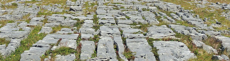
The Aran Islands are one of the finest examples of a Glacio-Karst landscape in the world and it is characterised by slabs of limestone, called clints, separated by deep cracks called grykes, giving a chocolate-bar structure to the landscape. The best example is the rectangular rock pool called Poll na bPeist (The Pool of the Sea Serpents) on Inis Mor.
In Aran limestone, there are many fossils including gastropods, corals, sea lilies, brachiopods and vertebrates.
Around the Aran landscape, there are also large granite boulders called 'glacial erratics' dumped on the islands when the ice melted.
These rocks are harder than the limestone and they were used locally as bowls, mortars for crushing grain and shellfish or as holy water fonts.