Wild Nephin National Park in Co. Mayo
Established in November 1998, Ballycroy National Park was renamed Wild Nephin National Park after a massive expansion in 2018.
It incorporates 11,000 hectares of Atlantic blanket bog and mountainous terrain. Sited on the western seaboard in northwest Mayo, overlooked by the Nephin Beg mountain range, it is one of the last intact active blanket bog systems in Ireland and Western Europe. It is Ireland’s sixth National Park and is part of the Owenduff/Nephin Complex Special Area of Conservation (SAC) and Special Protection Area (SPA). Access to the National Park can also be gained by walking along the Bangor Trail, a well-trodden route which possibly dates back to 16th century. Ballycroy National Park is managed by the National Parks & Wildlife Service of the Department of Arts, Heritage and the Gaeltacht.
The Park protects a variety of important habitats, the predominant one being the active Atlantic blanket bog, which covers most of the Park area. Other habitats include alpine and wet and dry heaths, upland grassland, lakes, and 2 rivers - the Owenduff and Tarsaghaun - each of which flow into the sea northwest of Ballycroy.
Corrie lakes in the Wild Nephin National Park, such as Corryloughaphuill Lough, are evidence of glacial activity over the past 2.5 million years and glacial boulder clay at the southern edge of the Nephin beg mountain range, is also indicative of glaciation.
Flora
A fascinating array of plants inhabit the National Park. Within the bog habitat are spaghnum mosses, bog cotton, black bog rushes, deer-grass, bell and ling heather, orchids, milkwort, sundew, lichens, crowberry and bilberry, to name but a few. Some well-developed flora exists on the margins of the lakes and bog pools, including bog bean, bulbous rushes, common spike-rushes, water lobelia and pipewort. Other rare plants found in the Park include the ivy-leaved bellflower, marsh saxifrage, purple saxifrage, alpine meadow rue, least willow and stiff sedge.
Fauna
An extensive range of fauna including birds, mammals and insects inhabit the Park. Amongst the bird species to be found in the Park are red grouse, ravens, hooded crows, whooper swans, woodcock, skylarks, dippers, common sandpipers, meadow pipits and dunlin. Some of the rarer species include Greenland White-fronted Geese, who are present between October and April, while a small population of Golden Plover breed in the summer on the upland areas of the National Park. Foxes, non-native red deer, mountain hares, badgers, bats, otters and feral American mink are amongst the mammal species resident in the Park. The Owenduff and Tarsaghaun rivers are notable for salmon and sea trout and other rivers and lakes in the area contain brown trout.
A multitude of bog pools in the Park attract many waterborne insects including dragonflies, damselflies, common bluetips, heathland skimmers, moorland hawkers, common darters, four-spotted chasers and spring redtails, to name but a few.
Archaeology
Wild Nephin National Park and nearby areas are rich in archaeological and historical sites, including promontory forts and crannógs.
Lios Na Gaoithe
Lios Na Gaoithe is a ring fort. Its Irish name means “The Windy Fort” and is quoted in the Mayo "Cattle raiding" saga - The Tain Bo Flidais. It is located in the Letterkeen Wood within the Nephin Mountain Range. It is a very well-preserved monument and was excavated in the 1950s. A burial site dating back to the Bronze Age was discovered beneath the ringfort, while the circular ring dates back to Christian times. Unearthed items such as food vessels, glass beads, and bracelets indicated that the people who lived there were also traders.
Daithí Bán
A cairn stands at the summit of the mountain Slieve Carr, also known as Corslieve.
According to folklore, the cairn is the location of the ring fort built by Daithí Bán, an unruly and troublemaking giant. There are a few different stories about him.
One story tells that three monks wanted to free the area from him. They challenged him to cross the lake at Bellacorick, but the muddy bottom lake trapped him, so he drowned. The monks buried him on the island of the lake, nowadays known as Lough Dahybaun, the Daithí Bán Lake.
Another legend tells Daithí Bán was a giant who lived in the Nephin mountains behind Ballycroy. He was a hunter who enjoyed hunting for deer but loved the taste of wild salmon the most. He never hesitated to jump into the clear water of the Atlantic Ocean to catch the fish, but like the Greek Hero, Orion, he was tricked into a watery grave. His image was cast into the night skies above the Wild Nephin Ballycroy National Park and can be easily seen from Winter to Spring.
A mix of these two stories tells he was a great local chieftain. He fought his enemies led by three monks
on the shore of Lough Dahybaun and died in that battle. His people buried him on the mountain close to the stars so he could watch his kingdom from up there.
The Fairy Fort
Crinn an Sí, in Irish, meaning the fairy tree, is a stone fort located near Derrybrook Lough.
According to a local story, men from the close area of Srahmore stole stones from the fort. On that very night, a curse fell on the village: nobody could sleep, animals were nervous, and the women were very worried about this. The following morning, the women told the men to bring back all the stones they took from the fort. They obeyed, and as soon as every stone was back to the fort, the peace descended on the village and the nearby hills.
Mayo International Dark Sky Park
In May 2016 the International Dark-Sky Association (IDA) granted the Gold-Tier International Dark Sky Park status to Ballycroy National Park and Wild Nephin Wilderness and recognised this area as the Mayo International Dark Sky Park, the first of this kind in Ireland. This wonderful recognition has been awarded for the pristine dark skies, unspoiled nature and nocturnal wildlife. The new park expands over 110 square kilometres of Atlantic blanket bog, forest and mountains.
Visiting astronomers and stargazers will benefit from many signature viewing sites with easy access and parking facilities. The sites are located in wonderful areas such as Claggan Mountain Boardwalk, Letterkeen Bothy and Ballycroy National Park Visitor Centre. They will be able to admire the splendour of Mayo’s starry sky and observe the Milky Way stretching across the park’s incredibly dark night sky, the Andromeda Galaxy and the magnificent constellation of Orion in winter.
On clear nights, more than 4500 twinkling stars can be seen in pristine skies above the park due to the total absence of light pollution.
Wild Nephin
Letterkeen is the access point to the main body of the park and the Letterkeen Loops offer three moderate-difficult walks:
-
Bothy Loop, 6 km long, blue marker, 2 hours, moderate fitness level required.
-
Lough Aroher, 10 km long, red marker, 3-3.5 hours, high moderate fitness level required.
- Letterkeen Loop, 12km long, purple marker, 4-5 hours, high fitness level required.
At the walks’ starting point there is a perfect area where to park the car, picnic, spot wildlife and shelter in the Robert Lloyd Praeger bothy.
Claggan Mountain Coastal Trail
This 2 km long trail winds along the stunning coastal bay boardwalk route.
It is situated 8km from the Visitor Centre and has an excellent parking area. It offers panoramic views East to the National Park mountains, South towards Claggan Mountain (382m) and West, across the inlet, to Achill Island.
This area is locally known as Ros na Finne or Wood of the Waves, and here the sea meets the bog. Here some thousand years old tree stumps can be seen along with otters, waders and divers. It is also the perfect corners for bird watching.
The wooden boardwalk runs above the bog so walkers can admire the fascinating array of bog plants and read the interpretation boards.
The Bangor Trail
The Bangor Trail is an arduous and remote hiking trail, approx 40km in length. The full trail, from Bangor to Newport, is almost 40km long. It can be shortened to 26km by leaving a car at or being collected at Letterkeen.
It is a waymarked walking trail taking a route south from Bangor Erris through the remote Nephin Beg mountain range to Newport, passing through Owenduff Bog.
This trail, which is mainly blanket bog terrain, follows an old drover path possibly dating from the Iron Age and used to be the main route from Bangor to Newport, dating back to the 16th century.
Along the route, there is evidence of previous human habitation, mostly from the mid 19th century when population pressure in this area was intense, immediately preceding the Great Famine.
The Bangor Trail can take at least 10 hours to complete, 12 hours or more are likely. Walkers need to be experienced and well equipped. On a clear day, walkers are rewarded with wonderful views over the surrounding landscape, as well as a great variety of wildlife, flora and fauna.
This area is Ireland’s biggest wilderness and is a remote and quiet place. Irish hares, red deer, frogs, red grouse as well as other birds and summer wildflowers can be spotted.
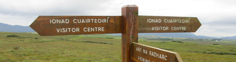
Visitor Centre
The Ballycroy Visitor Centre is located in the village of Ballycroy on the N59 road between Mulranny and Bangor. The Visitor Centre is the main information point for Wild Nephin National Park. There is an interactive exhibition on the habitats of the surrounding area at the Visitor Centre as well as a Nature Trail with pond, interpretation panels and viewing point. There is an education programme at the Visitor Centre for visiting primary and secondary schools. The Visitor Centre has tea rooms serving light snacks, soup and sandwiches.
Directions
From Newport
Follow the N59 road for 16km from Newport to Mulranny. After Mulranny village the N59 turns right at a junction signposted 'Ballycroy National Park Visitor Centre'. The village of Ballycroy is a further 14km along this road and in the village there is a sign for the Visitor Centre. Turn right and the Visitor Centre main entrance is 300 metres on the right hand side.
From Bangor Erris
Follow the N59 south, in the direction of Mulranny, for 17km to the village of Ballycroy. At the junction in the village turn left at the sign for the Visitor Centre and travel 300 metres to the main entrance on the right hand side.
Shuttle Bus Service
Starting on Tuesday, June 4th 2024, the free Shuttle Bus Service will resume in the summer of 2024. It will run from Tuesday to Saturday for June, July and August. The route runs from Bangor Erris to Westport and vice versa, stopping at Newport, Letterkeen, Mulranny, the Claggan Mountain Coastal Trail, and the Ballycroy Visitor Centre.