The Portacloy Loop - Cliff Walk in Co. Mayo
Portacloy Loop is a 18km long loop walk starting and finishing at Portacloy Beach (Green Coast Award Beach for 2017).
This moderate walk follows the coastline and the line of the cliffs reaching 255m above sea level at Benwee Head.
Along the trail spectacular views come into sight: the Stags of Broadhaven, Mullet Peninsula, Achill Island and The Hills of Donegal and further west off the coast Kid Island.
At Rinroe Peninsula the track winds along a bog road passing a graveyard. At a V-junction on the top of a hill, following right, a knitting factory and old school come into view. At the end of the track, turning right and following north eastwards, the commonage crosses first a stream then another one called “The River of The Red Fairy” (in Irish Abhainn na Si Ruaidhe) and then it leads back to Portacloy Beach.
The estimated time is 4 hour 40 mins.
DID YOU KNOW?
EIRE 63
Eire 63 is a stone aerial mark visible from the air. It was built during the Second World War as well “Teaching a’Watch”, a building used as a station to monitor warships off the coast, not so far from the mark.
THE STAGS OF BROADHAVEN
The Stags of Broadhaven are located 3km off Erris Head and are 1.6 billion years old. They are four pyramid shaped rocky islands which rise to over 70 metres above sea level: Teach Mor is 92 metres in high, Teach Donal O’Clerigh 93 metres, Teach Beg 71 metres and An-t-Oighean 75 metres.
The Stags are uninhabited and over the centuries neither monks, pirates or graziers occupied the islands because the landing was difficult and nearly impossible. They are home to a large number of seabirds.
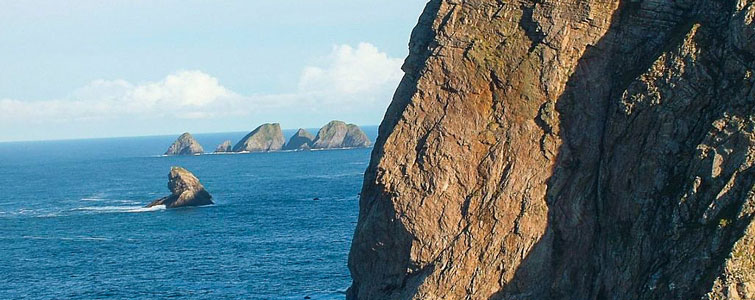
BENWEE HEAD
Benwee Head offers some of the most dramatic coastal scenery on the Wild Atlantic Way and commands spectacular views on majestic cliffs, rugged headlands, rocky coves and jagged stacks.
The cliffs date back about 600 million years ago and are made of Dalradian quartzite. The stratification of the rocks is vertical or lies at all angles.
The high cliffs were formed by the drift of the American continent against Europe as the similar cliffs at Slieve League in Donegal.
Benwee Head at 255m is higher than the Cliffs of Moher. It takes its name from the yellow colour of the quartzite: “The Yellow Peak” in Irish “Binn Bhui”.
THE GRAVEYARD
According to local folklore, the graveyard is the burial place of St. Gallagan, where a large mound stands. Here, there is a stone slab with a Maltese Cross carved on it. It dates back to the Early Christian Period.
AN DUNA
An Duna is the remains of a promontory fort built in the fifth century BC (Iron Age) and it is thought it had been occupied until the Early Christian Period.
It was defended on three sides by the sea and on the landward by a wall.
Promontory forts are typical on the West coast of Ireland and suggest a separate building tradition and not an adaptation of the local hill fort type to a coastal situation.