Clew Bay Archeological Trail
Stage 2 Murrisk, Muraisc (Sea Marsh)
The Murrisk section includes 5 sites:
1: ANNAGH-KILLADANGAN ARCHAEOLOGICAL COMPLEX, EANACH CHOILL AN DINGING ( MARSH, THE WOOD OF THE FORTRESS)
This archaeological complex is located in an area of salt marsh on the south-eastern shore of Clew Bay. The site is accessible all year round except in springtime when the tides can submerge it.
It dates from Bronze Age and includes an oval enclosure and the most remarkable row of five standing stones; four stones are upright and the fifth has fallen down. This last stone points towards the Reek. The function of these standing stones is still a mystery. Archaeologists think they could be mark bronze age burials, territorial markers or even key solar and lunar events markers.
The most recognised theory is that the standing stones mark the winter solstice. The height of these stones increases from north to south drawing the eye up to a niche on the mountainside. On 21st December at about 1.50pm the sun dips into this niche directly in line with the row of stones.
There is also a folk tale about these stones. The King of Killadangan, Queen Maeve’s brother in law, whose name is unknown, sent Thulera, his lazy servant, to the stones to check the upcoming tide. The king was waiting to force the sea and tide under his command. But the lazy servant fell asleep and both king and servant drowned.
2: MURRISK ABBEY
Murrisk Abbey was a former Augustinian Friary located quite close to the sea overlooking Clew Bay at the northern base of Croagh Patrick. It was built on the site of a previous church founded by St. Patrick and is a well-known ancient landmark.
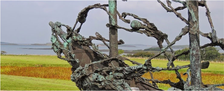
3: NATIONAL FAMINE MONUMENT
One million people died in Ireland from disease and starvation during the Great Famine of 1845 to 1849, arguably the single greatest disaster in Irish history, which had a devastating impact on the Irish language and culture.
Renowned sculptor, John Behan, was commissioned by the Government to create a sculpture that would encompass the magnitude of the suffering and loss endured by the people of Ireland during the famine. The result was the Famine Ship unveiled in July 1997 by President Mary Robinson.
The Monument, made of bronze, depicts a “Coffin Ship” with the sails fashioned like skeletons. It symbolises the many people who died during the crossings to the New World lending the name to these ill-fated vessels.
4: STATUE OF ST PATRICK
The statue of St Patrick is located at the start of the path up to Croagh Patrick.
It was erected in 1928 by Fr. Patrick Patterson with part of the money collect in America for St Mary Church in Westport.
The statue is not one of the stations along the pilgrim route, but it can be considered as the starting and finishing point of the journey up the Holy Mountain.
5: GLASPATRICK CHURCH, GLAISE PHADRAIG (PATRICK’S STREAM)
The ruins of the church at Glaspatrick, 2 kilometres west on the Louisburgh road from Murrisk Abbey, are overgrown and in poor condition, but it is thought that this church belongs to the medieval period probably the early 12th century.
Glaspatrick was one of the original churches founded by St Patrick in the area, along with Aughagower and Teampall Padraig on the summit of the Holy Mountain.
According to legend, there is another connection to St Patrick. Totmael, who was the saint’s charioteer, is said to have died in this area and to have buried in Glaspatrick.
A cemetery surrounding this church is small, and was mainly used for the burial of islanders who lived on the small islands within Clew Bay. The inscriptions on the headstones span many decades, and the graveyard is still used for occasional burials.
A Holy Well still exists in the graveyard situated beside the outer dry stone wall.