Croagh Patrick Walk in Co. Mayo
Croagh Patrick, one of Mayo's most famous landmarks is located six miles west of Westport on the Louisburgh Road.
Most people who climb this holy mountain do so along the traditional pilgrim route from Murrisk Abbey, although some pilgrims complete 'the Pilgrim way'- the Tochair Padraig from Ballintubber Abbey.
William Makepeace Thackeray in The Irish Sketch Book (1842) described Croagh Patrick thus:
It is clothed in the most magnificent violet-colour, and a couple of round clouds were exploding, as it were, from the summit, that part of them towards the sea lighted up with the most delicate gold and rose-colour. In recent years an archaeological survey uncovered quite a wide range of ancient sites throughout the mountain and it's hinterland. These discoveries include fulachta fiadha (Bronze Age cooking sites), megalithic tombs, standing stones, burial mounds, ringforts, monastic sites and cillins (or lisheens) (burial places of unbaptised children).
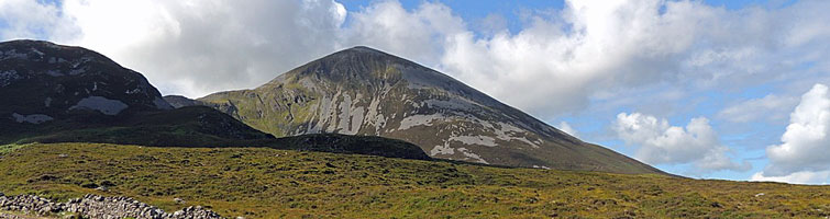
An interesting ridge walk can be taken from Belclare Bridge to Lecanvey, waking along the crest of the mountain that reaches a height of 2,510 ft. This route provides magnificent views of Clew Bay and it's countless islands. Tradition has it that there are 365 islands, one for every day of the year. These islands are part of the drumlin topography, now submerged by the sea. The view from along the route is breathtaking.
THE ROUTE
To reach the starting point of our walk follow the R35 road out of Westport (to Louisburgh) for about three miles. (It is best if you use two cars leaving one at Lecanvey Village saving you a long five-mile road walk at the end of your day's climb).
Our walk starts from Belclare Bridge, which crosses the Owenwee River. After you pass the garage at Belclare a sign announces The Owenwee River.
Immediately after crossing the bridge take a left turn and follow this road straight uphill, then turn right when you reach a red and yellow waymarker for The Western Way.
Turn right along this narrow road which crosses through a wooded slope which is rich in flora typical of an Irish hedgerow.
Continue until you pass a farm then turn left along a track which is again marked by signs indicating The Western Way Route.
Continue along this track which is rocky underfoot and covered with heather. There is a fence on both sides but you will reach a gate later on your right.
Go through this gate and continue straight ahead until you reach a tall stone wall (known locally as The Deer Wall) and fence.
Cross the fence and follow the wall to your left-hand side. Continue along the wall, which passes through a noticeable gap in the hills.
Leave the course of the wall and follow a narrow track through the heather clad slope until you reach a stony area with a clear view of Croagh Patrick's summit.
Around here you will meet the route followed by the Tochair Padraig which you follow for a short while until you reach the main route followed by pilgrims climbing from Murrisk.
Continue along this route passing a toilet block on your left. This path continues past a cairn known as Leacht Beannain.
The conical summit is reached by traversing through the quartzite boulders, which can be dangerous in wet weather.
Use extreme caution while climbing this section as the boulders can fall easily. Most accidents on the mountain occur in this area.
As you reach the summit a white chapel becomes visible. St. Patrick's Bed, the remains of an ancient stone fort and a trig point at 764m (2,510ft) are also to be seen on the summit.
Go straight ahead at the summit. From here you will have an exquisite view of Connemara, Clew Bay, the Nephin Beg mountain range, Achill and Clare Island.
Follow a zigzag path down the steep western slopes. The descent to Lecanvey is best if you deviate towards the right through the stony and heather-coated shoulder.
The path takes you towards a stream. When you reach the stream turn right and follow the stream down a more moderate gradient. As you reach a wall, which is easily crossed, you will then pass through a hemmed in area of moorland including some areas of thorny shrubland.
Continue along the path and later a trackway, which leads to a gate. Pass through the gate into a minor road and turn left along the road which soon leads you to the village of Lecanvey and Staunton's Pub.
Turn right on reaching the village of Lecanvey and follow the main road for approx. five miles until you reach the starting point once more, passing through the village of Murrisk . Should you have brought a second car you will now appreciate it.
Distance of Walk: 12-km (7 miles) approx. Height of Ascent: 764m(2,510ft.)
By Brian Hoban